MB Geolocation
MB Geolocation helps you fill in address fields (street address, zip code, city, state, and country) quickly by using Geocoding API from Google Maps/Open Street Maps.

Configuration
To make the geolocation work, you need to configure 4 things:
- Enable the geolocation API
- Setup the field group settings
- Setup the ID for the address field to make it suggests addresses from geolocation API
- Setup the ID (or binding ID) for other fields to retrieve data from geolocation API when selecting an address
Follow each step below.
Geolocation API
Create a project in the Google Cloud Platform Console, and enable the following APIs:
- Google Maps API
- Geocoding API
- Places API
After that, create an API key for Google Maps. You'll need this key to perform any call to Google Maps platform.
If you use Open Street Maps, then you can bypass this step. Open Street Maps doesn't require any configuration.
Field group settings
If you use Open Street Maps, you need to add an Open Street Maps field to your field group. Then add geo to your field group custom settings in the MB Builder like this:
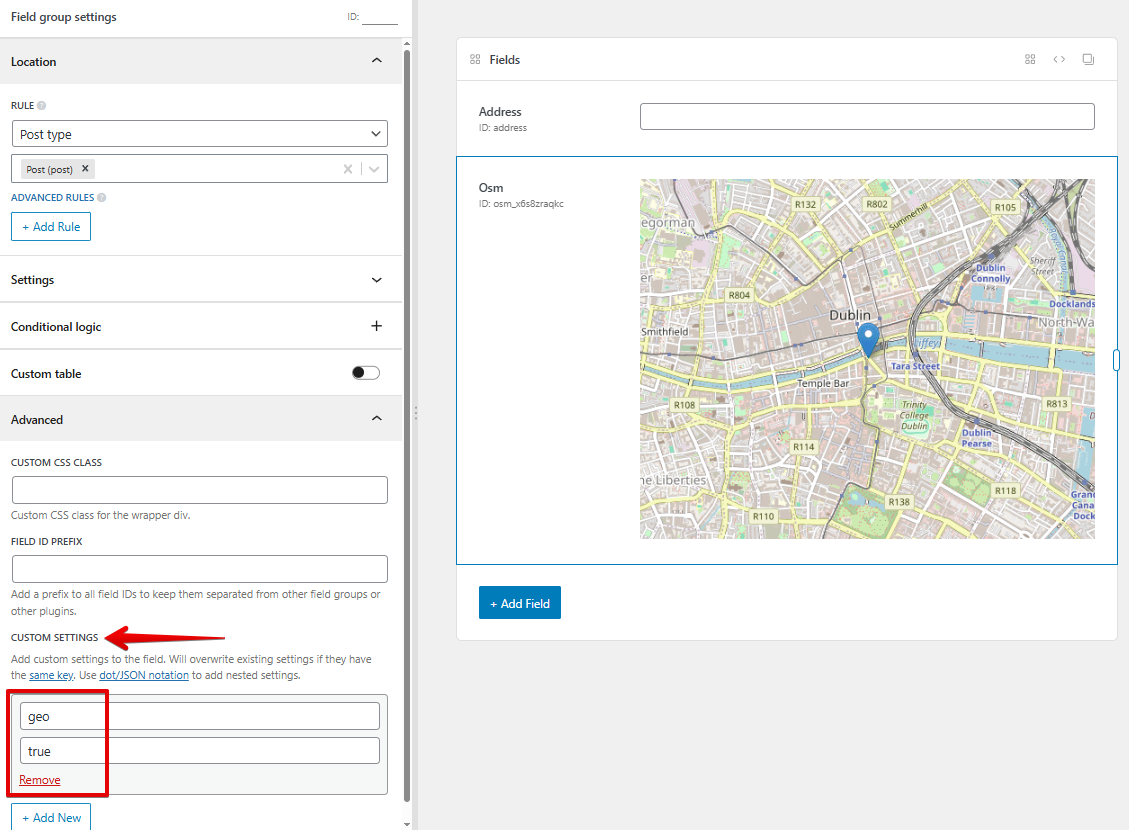
If you use code, then add this line to your field group settings:
'geo' => true,
If you use Google Maps, it's not required to add a Google Maps field to your field group. To enable geolocation, add the following custom settings in the field group settings in the MB Builder like this:
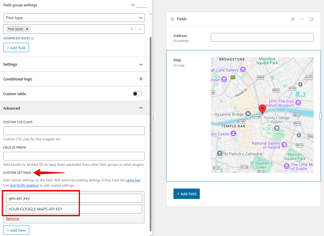
If you use code, then add this line to your field group settings:
'geo' => [
    'api_key' => 'YOUR API KEY',
],
If you have a Google Maps field in your field group, then you can set the Google API key once, either for the Geolocation extension (as above) or for the map field. No need to enter the same key for both of them.
You can also add options to Geolocation, which can contains these properties:
types: array of geocode types:geocode: only geocoding results, no business results.address: only geocoding results with a precise address.establishment: business results.(cities): only results that match eitherlocalityoradministrative_area3.(regions): any result matching the following types:localitysublocalitypostal_codecountryadministrative_area1administrative_area2
componentRestrictions: restrict results to a specific country, must be ISO 3166-1 Alpha-2 compatible country code. You can find code information at Wikipedia: List of ISO 3166 country codes.
Examples:
// Restrict the result in Australia only
'geo' => [
    'api_key' => 'YOUR API KEY',
    'componentRestrictions' => [
        'country' => 'au'
    ],
],

// Return only business results
'geo' => [
    'api_key' => 'YOUR API KEY',
    'types' => ['establishment'],
],

// Return only cities and business results
'geo' => [
    'api_key' => 'YOUR API KEY',
    'types' => ['(cities)', 'establishment'],
],
Address field
The address field is used to retrieve the suggestions from the Geolocation API. To add an address field, add a text field with an ID that starts with address (like address or address_something)...
Other fields
When you select an address from autocomplete list, the geolocation API will return a list of address components. To make the field retrieve the data, set the field's ID the same as one of the address components.
For example, if you create a text field with ID locality, when you select an address, the city of the address will be filled into this text field.
Here is the list of components for Google Maps:
| Component | Description |
|---|---|
street_address | indicates a precise street address. |
route | indicates a named route (such as "US 101"). |
intersection | indicates a major intersection, usually of two major roads. |
political | indicates a political entity. Usually, this type indicates a polygon of some civil administration. |
country | indicates the national political entity and is typically the highest order type returned by the Geocoder. |
administrative_area_level_1 | indicates a first-order civil entity below the country level. Within the United States, these administrative levels are states. Not all nations exhibit these administrative levels. |
administrative_area_level_2 | indicates a second-order civil entity below the country level. Within the United States, these administrative levels are counties. Not all nations exhibit these administrative levels. |
administrative_area_level_3 | indicates a third-order civil entity below the country level. This type indicates a minor civil division. Not all nations exhibit these administrative levels. |
administrative_area_level_4 | indicates a fourth-order civil entity below the country level. This type indicates a minor civil division. Not all nations exhibit these administrative levels. |
administrative_area_level_5 | indicates a fifth-order civil entity below the country level. This type indicates a minor civil division. Not all nations exhibit these administrative levels. |
colloquial_area | indicates a commonly-used alternative name for the entity. |
locality | indicates an incorporated city or town political entity. |
sublocality | indicates a first-order civil entity below a locality. Some locations may receive one of the additional types: sublocality_level_1 through to sublocality_level_5. Each sublocality |
neighborhood | indicates a named neighborhood. |
premise | indicates a named location, usually a building or collection of buildings with a common name |
subpremise | indicates the first-order entity below a named location, usually a singular building within a collection of buildings with a common name. |
postal_code | indicates a postal code as used to address postal mail within the country. |
natural_feature | indicates a prominent natural feature. |
airport | indicates an airport. |
park | indicates a named park. |
post_box | indicates a specific postal box. |
street_number | indicates the precise street number. |
floor | indicates the floor of a building address. |
room | indicates the room of a building address. |
lat | indicates latitude of the result |
lng | indicates longitude of the result |
geometry | same as latitude,longitude |
formatted_address | returns human-readable complete address |
id | unique id of current location |
url | url of current location |
opening_hours | Opening hours |
phone | Phone number |
formatted_phone_number | Formatted phone number |
international_phone_number | International phone number |
website | Website URL |
rating | Rating value |
user_ratings_total | Total number of ratings by users |
For more information about address components visit: Google Address Component Types
Here are the address components for Open Street Maps:
| Component | Description |
|---|---|
building | Building address |
house_number | House number |
aeroway | Aeroway |
road | Road address |
neighbourhood | Neighbourhood |
suburb | Suburb |
village | Village |
town | Town |
city | City |
county | County |
state | State |
postcode | Postcode |
country | Country |
country_code | Country code |
Advanced
Sometimes you don't want the fields to have the exact ID as the address components, or if you want to combine multiple components into one field, then follow the guides below.
Long and short names
Let's say we have a country named 'Australia'. The long name is 'Australia' and the short name is 'AU'. If we have a state named 'Queensland', 'Queensland' is the long name and 'QLD' is the short name.
By default, MB Geolocation will populate the long name of the field. But you can use the short name by adding _short at the end of field ID. For example: administrative_area_level_1_short, country_short.
This feature is available for Google Maps only.
Custom binding
Let's say we have a field with id dummy_field, this field ID is not in the address component list so the plugin won't auto-populate data to it. To make the plugin auto-populate data (administrative_area_level_1) to that field, add the following parameter to the field:
With MB Builder:

or with code:
'binding' => 'administrative_area_level_1', // returns 'Queensland'
You can tell that field to use the short version by prepending the short: keyword:

'binding' => 'short:administrative_area_level_1', // returns 'QLD'
You can also merge two fields, and add any character you want to bind to that field. Like so:

'binding' => 'city + " " + country', // returns QLD Australia
Multiple addresses
In case you have multiple "groups" of address fields, such as address details for head office and address details for a company branch. In each group, there is an autocomplete address field. And it will auto-populate only fields in the group, e.g. the address for head office only populates the fields in the head office group, not in the company branch.
In this case, please set another attribute 'address_field' => 'address_id' for each field in the group. See an example code below:

If you do with code, then your field group looks like this:
/**
 * Head office
 */

// Address
[
    'id' => 'address_ho',
    'name' => 'Address - Head Office',
],
// City
[
    'id' => 'city_ho',
    'name' => 'City - Head Office',
    'binding' => 'locality',
    'address_field' => 'address_ho',
],

/**
 * A company branch
 */

// Address
[
    'id' => 'address_br',
    'name' => 'Address - Branch',
],
// City
[
    'id' => 'city_br',
    'name' => 'City - Branch',
    'binding' => 'locality',
    'address_field' => 'address_br',
],
Two-way data binding
If you have a map field, then whenever you change an address or manually change the value of latitude and longitude fields, the pin on the map will change according to the new location.
And whenever you change the pin location, the latitude and longitude will change (if you have these fields).
However, if you change the pin location, the address field will NOT change.