Google Maps
The Google Maps field lets you select and save a location directly on a map. It works together with an address text field, which supports autocomplete powered by the Google Maps Geocoding service.
You can set a location in two ways:
- Type an address into the text field (autocomplete helps you quickly find the place).
- Click on the map or drag the marker to a new spot. The field will then save the coordinates automatically.
Screenshots

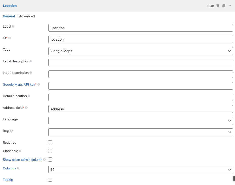
Settings
In addition to the common field settings, this field has the following options:
| Name | Key | Description |
|---|---|---|
| Google Maps API key | api_key | Your Google Maps API key. Get one here. Required. |
| Default location | std | The map's default location when it first loads. Format: '53.346881,-6.258860' (latitude, longitude). If not set, the map defaults to Dublin, Ireland. |
| Address field | address_field | The ID of the address field. For multiple fields, separate IDs with commas. Required. |
| Language | language | Set the map language. See the full list of language codes. |
| Region | region | A country code top-level domain. This helps autocomplete suggest results based on a specific region. Learn more. |
| Marker draggable | marker_draggable | Determines whether the marker can be dragged. Boolean, default is true. When set to false, the marker cannot be moved on the map — the location can only be set by searching for an address (Google will place the marker automatically). |
You must create a text field for the address input, and pass its ID to the map's Address field setting.
The address_field can also be a list of multiple field IDs, separated by commas (e.g. street,city,state). In this case:
- You can use both text and select fields.
- Autocomplete will not work. Instead, the plugin combines the values from those fields to search for the location and updates the map whenever any field changes.
Don't forget to enable the Geocoding API in your Google Cloud project - it's required for the autocomplete feature!
Example field setup in code:
// Address field
[
    'id'   => 'my_address',
    'name' => 'Address',
    'type' => 'text',
],
// Map field
[
    'id'            => 'map',
    'name'          => 'Location',
    'type'          => 'map',
    'std'           => '-6.233406,-35.049906,15',
    'address_field' => 'my_address',
    'api_key'       => 'XXXXXXXXX',
],
Data
The field saves the location as:
latitude,longitude,zoom
Example: 53.346881,-6.258860,14
Template usage
Displaying a map
To show the map on the frontend, use rwmb_the_value() with extra parameters:
<h2>Google Maps</h2>
<?php
$args = [
    'width'        => '640px',
    'height'       => '480px',
    'zoom'         => 14,
    'marker'       => true,
    'marker_icon'  => 'https://url_to_icon.png',
    'marker_title' => 'Click me',
    'info_window'  => '<h3>Title</h3><p>Content</p>.',
];
rwmb_the_value( 'my_field_id', $args );
?>
Available parameters:
| Name | Description |
|---|---|
width | Map width. Default: 640px. Accepts % or px. |
height | Map height. Default: 480px. Accepts % or px. |
zoom | Map zoom level. Default: value set in the admin, or 14 if not set. |
marker | Show marker? true (default) or false. |
marker_icon | URL to a custom marker icon. Optional. |
marker_title | Marker tooltip (shows on hover). |
info_window | Content shown when clicking the marker. HTML allowed. Avoid quotes inside to prevent JavaScript issues. |
js_options | Pass custom JavaScript options. Reference. |
The code below shows how to use js_options for advanced control how the map is displayed:
$args = [
    'width'      => '640px',
    'height'     => '480px',
    'js_options' => [
        'mapTypeId'   => 'HYBRID',
        'zoomControl' => false,
    ],
];
rwmb_the_value( 'my_field_id', $args );
Getting the raw field value
If you don't need to render the map but just want the coordinates:
$location = rwmb_get_value( $field_id );
echo $location['latitude'];
echo $location['longitude'];
echo $location['zoom'];
See more about rwmb_get_value().
Displaying a map inside a group
If the map is part of a group field, the helper functions above won't work. Instead, use the built-in RWMB_Map_Field::render_map() helper:
$args = [
    'width'      => '640px',
    'height'     => '480px',
    'js_options' => [
        'mapTypeId'   => 'HYBRID',
        'zoomControl' => false,
    ],
];
$group_values = rwmb_meta( 'group_id' );
$args = [
    'api_key' => 'your-API-key'
];
// If the group is cloneable
foreach ( $group_values as $group_value ) {
    echo RWMB_Map_Field::render_map( $group_value['map_id'], $args );
}
The helper function accepts:
| Name | Description |
|---|---|
$location | Map location in the format latitude,longitude[,zoom] (zoom is optional). Same as the map field value. |
$args | Additional display options. Same as in rwmb_the_value(). |
Filters
rwmb_google_maps_url
This filter lets you modify the Google Maps script URL - for example, to add extra libraries. It receives the script URL as a parameter and should return the modified URL.
For example, the code below adds "geometry" library to the Google Maps script:
add_filter( 'rwmb_google_maps_url', function ( $url ) {
    return add_query_arg( 'libraries', 'geometry', $url );
} );